
Snow and dangerous travel conditions are expected in parts of Maryland on Saturday as a winter storm moves through the region, according to the National Weather Service.
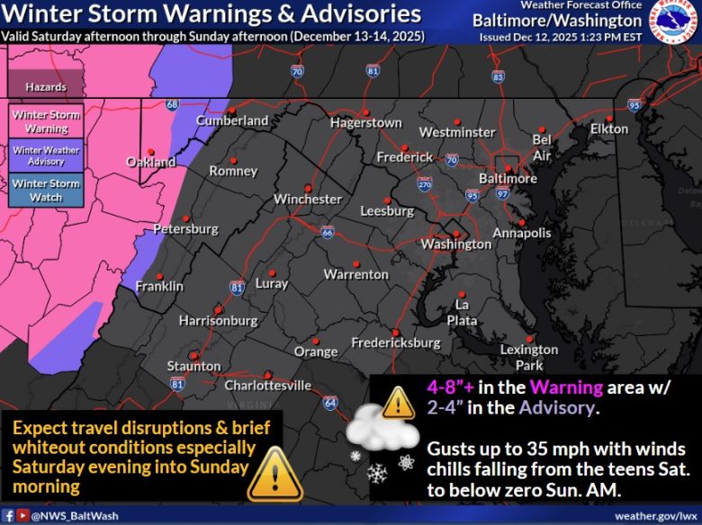
What’s Happening: Winter Storm Warnings and Advisories are in effect for western Maryland, mainly the Allegheny Mountains, from Saturday afternoon through Sunday afternoon.
- Snow totals of 4 to 8 inches are expected in warning areas
- Advisory areas could see 2 to 4 inches of snow
What’s Important: Strong winds will combine with falling snow to create brief whiteout conditions, especially Saturday evening into early Sunday. Wind gusts could reach 35 miles per hour, making roads dangerous and travel slow.
Where It Hits: The highest impacts are expected in Garrett and western Allegany counties, where elevations are higher and snow will fall longer. Central Maryland, including the Baltimore and Washington suburbs, is not included in warnings at this time.
What Comes Next: Wind chills are expected to drop into the teens Saturday night and could fall to zero or below by early Sunday, increasing the risk of exposure and icy roads even after snow ends.
Drivers are urged to avoid unnecessary travel during the height of the storm and check road conditions before heading out.
Discover more from The Free State Press
Subscribe to get the latest posts sent to your email.